Diagram template
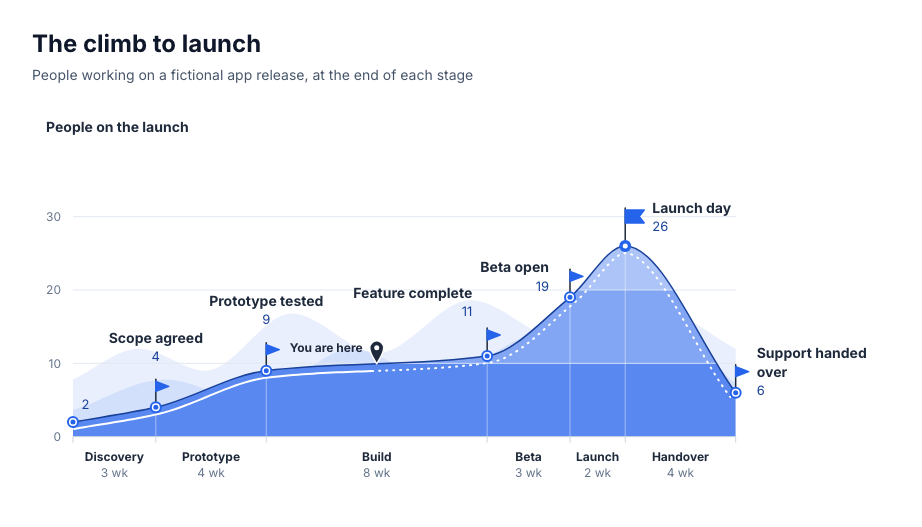
Journey: trail elevation profile
A journey of ordered stages drawn as a hiking-map elevation profile: each stage's width is its duration, the terrain's height at every stage boundary is an exact value on a labelled scale, and tonal elevation bands step at the scale's ticks. A trail follows the ridge, solid as far as the current position and dashed beyond it; a flagged camp at each boundary carries its name and value, and the highest camp flies the summit flag.
Categories
Included in
Max
When to use it
Suits one measure that rises and eases across the stages of a journey: effort across a product launch, difficulty along a learning curve, friction along a customer journey, risk across project phases, cumulative cost across a build. Needs 4 to 7 stages with a duration each in one unit, one non-negative value at the start and at the end of every stage, and optionally the stage in progress. Not for several measures, values known only per stage rather than at its boundaries, or negative values.
Adjust after generating
Change the style, colors, and font, and these options, as often as you like without spending credits.
- Typography
- Spacing
What you fill in
Describe your topic in plain words and the AI fills these in. You can edit every field afterwards.
- Value label
- Text
- Start
- Number
- Unit
- Text
- Stages
- 4 to 7, each with name, duration, label, and value
- Position
- Text
- Prefix
- Text
- Suffix
- Text
Related templates
All journey templates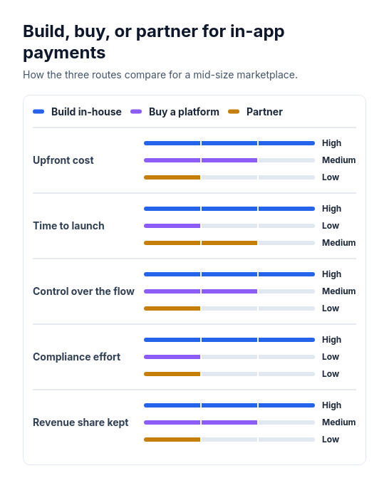 Attribute barsCompare two or three options across three to six attributes that can be scored or rated low, medium, or high, such as cost, speed, and effort.
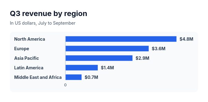 Bar chartCompare three to ten amounts of the same kind, such as sales by region, survey answers, or time per task.
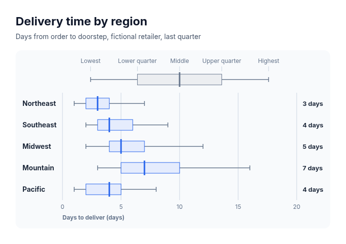 Box plotSuits comparing how values spread across groups when five summary numbers are known for each: delivery times by region, salaries by level, deal sizes by segment, response times by team, test scores by class.
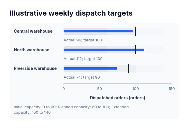 BulletActual-versus-target values sharing one nonnegative scale and explicitly supplied range boundaries.
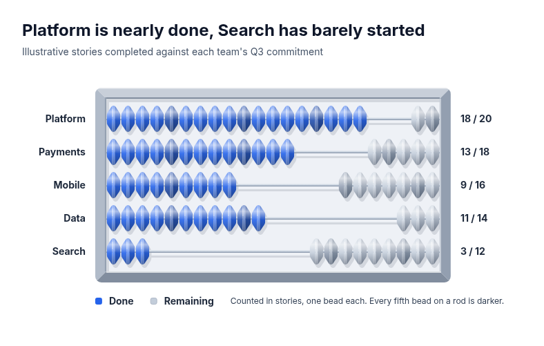 AbacusSuits small whole-number progress compared across a few rows, where each unit should stay countable: sprint or quota progress by team, seats filled by course, orders picked by warehouse, checklist items completed by site.
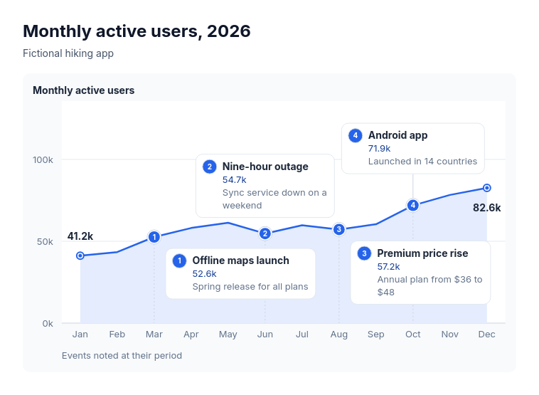 Annotated lineSuits explaining the turns in one measure over time: monthly active users with launches and outages, revenue with pricing changes, support volume with policy changes, website traffic with campaigns, headcount with reorganisations.